Public Access Birding Sites in White County, Tennessee
If you have information about other public access birding sites in this county, please send details to me at this e-mail address:
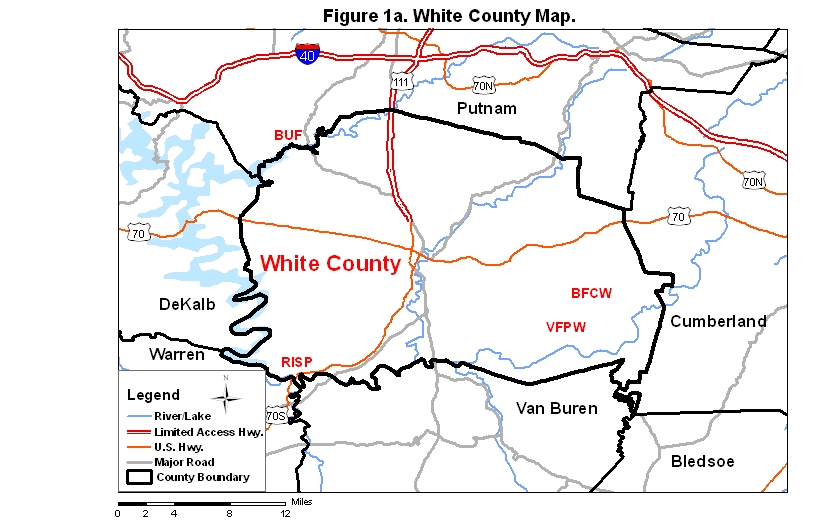
White County covers an area of 982 km2 (379.4 mi2). A map of the county—with the some sites noted below coded on it—is available via the following link:
The Bridgestone/Firestone Centennial Wilderness (BFCW), a TWRA Wildlife Management Area, is one of the premier birding sites in White County. Small pieces of this site are located in western Cumberland County and northern Van Buren County, but over 95% of the area is in White County. To get to the BFCW, take I-40 to exit 288 for Rt. 111 and go south to Sparta on Rt. 111. Take the exit for Rt. 70S and go east 11.1 miles toward Crossville, climbing the western escarpment of the Cumberland Plateau and proceeding onto the plateau itself, to Eastland Rd. on the right just after you enter the community of De Rossett. Take Eastland Rd. 5.85 miles to Scott's Gulf Rd. on the right. From that intersection you can access the BFCW by continuing on Eastland Rd. or by taking Scott's Gulf Rd. to the right. The main entrance to the area is 0.9 miles ahead on Eastland Rd. Park at the entrance and walk in (foot travel only is allowed); if the gate is closed, go 0.25 miles farther on Eastland Rd. to a parking area on the right where there is access to the site (foot travel only) through a gap in the fence. The large fields in this part of the wilderness host many birds of open country including Henslow's Sparrows. The edges of the ponds in the fields are good sites to look for Sedge and Marsh wrens during migration. On several occasions the small groups of pines in the fields have hosted Brown-headed Nuthatches.
If you drive down Scott's Gulf Rd., go 2 mi to the Polly Branch Trailhead on the left. From this trailhead you may hike two trails: the Chestnut Mountain Farm Trail and the Polly Branch Trail. The Chestnut Mountain Farm Trail is the more northerly of the two trails leading out from the Polly Branch Trailhead. This trail runs through forest for about 2.5 mi, and then it runs through fields and shrub-scrub habitat for another 1.5 mi before meeting a (somewhat poorly marked) connector trail that leads down to Clifty Creek (see two paragraphs down for discussion of the Caney Fork River Trail which also ends at Clifty Creek). You may take this connector down to Clifty Creek and loop back via the Caney Fork River Trail (very difficult and sometimes poorly marked) to the Polly Branch Trail (note: you must cross Copper Cascade to complete this loop; Copper Cascade can be dangerous to cross under high-water conditions).
The Polly Branch Trail is the more southerly of the two trails that lead out from the Polly Branch Trailhead. For 1.3 mi the trail is fairly level, traversing mixed forest; it then simultaneously intersects the Yellow Bluff Trail (on the right; see next paragraph) and a short spur trail to the Bee Overlook (straight ahead). The Polly Branch Trail continues to the left at this point, descending steeply to Polly Branch, crossing that stream, and passing a spur trail on the right to the Upper Polly Branch Falls. The Polly Branch Trail then intersects an old log road (note: this log road also leads uphill where in 0.15 mi it intersects the Chestnut Mountain Farm Trail) that it follows downhill to the Polly Branch campsite on the Caney Fork River, where you may access the Caney Fork River Trail going both upstream and downstream.
Various other access points to the BFCW are located farther down Scott's Gulf Rd. from the Polly Branch Trailhead. The first of these access points is about 1.5 mi distant and is the trailhead for the Yellow Bluff Trail; you may walk this fairly easy trail to the Yellow Bluff Overlook (nice view) in 0.3 mi, the Boar Gap Overlook (nice view) in about 1 mi, and the Bee Overlook (poor view even in winter) in about 2 mi (at the intersection with the Polly Branch Trail; see above). If you continue driving on Scott's Gulf Rd., you will come to a turn-around and a sign warning that the road is best driven in a four-wheel drive vehicle; two-wheel drive vehicles may actually proceed about another mile, but thereafter the sign's warning is quite accurate. Scott's Gulf Rd. ends at the Caney Fork River, near which there is the trailhead for the Caney Fork River Trail, which proceeds upriver 6 miles to the confluence of the Caney Fork River and Clifty Creek and downriver several miles, sometimes crossing the Caney Fork River itself (I have not yet walked this part of the BFCW trail system, so I cannot speak about it specifically, but it apparently takes one to, or at least near, the Scott Pinnacle, a famous landmark in these parts). The Caney Fork River Trail going upriver from Scott's Gulf Rd. is a difficult trail; it intersects the end of the Polly Branch Trail about 4 mi upriver from Scott's Gulf Rd, and it intersects Copper Cascade about 0.5 mi farther upriver from there (note: the trail crossing at Copper Cascade can be quite dangerous when there is much water coming down the cascade, so use extreme caution if you try to cross this "stream" under high-water conditions). The Caney Fork River Trail ends 1.5 mi upriver from Copper Cascade at the confluence with Clifty Creek, though there is a connector trail leading uphill to the Chestnut Mountain Farm Trail at that point.
Virgin Falls State Natural Area, formerly the Virgin Falls Pocket Wilderness (VFPW), may be accessed by following the directions for the Polly Branch trailhead to the Bridgestone/Firestone Centennial Wilderness, noted above. Go 0.1 miles past the Polly Branch Trailhead, and the trailhead for Virgin Falls is on the right. The trail in to Virgin Falls is a bit rugged, sometimes poorly marked, and four miles one way, so be sure to have the proper footgear and time allotment for the trip. You may also access this birding site from White's Cave Rd. via the trail to Rylander Cascade that is part of Lost Creek Falls State Natural Area. Distance to Virgin Falls along that trail is about 4.5 miles.
Lost Creek Falls State Natural Area is located along the west side of White's Cave Rd. just to the north of the Big Bottom WMA. Lost Creek Falls is quite spectacular during periods of heavy rainfall. Black-throated Green Warblers are among many species of warblers found at this site. Access to Virgin Falls State Natural Area is available via the trail to the Rylander Cascade; the trailhead for that trail is located along White's Cave Rd. about a half mile south of the parking area for the waterfalls near the boundary between Lost Creek Falls SNA and the Big Bottom WMA.
Big Bottom WMA is located at the intersection of Hickory Valley Rd. and White's Cave Rd. This site is accessible to the birding public during periods when hunting is not taking place. Part of this site borders a section of the Caney Fork River.
Dog Cove, a unit of Fall Creek Falls State Park, is located at the end of Lost Creek Rd. just to the east of where that road intersects with White's Cave Rd. This site includes a number of large fields located along the bottomlands of Lost Creek and Little Lost Creek. Old homesteads, including the Davis House, were once active in these fields. The Low Gap Trail leads to higher elevations along the west side of this park unit with a side trail to a small natural arch. Some information about surveys of birds and butterflies conducted during 2019 may be accessed via this link: Dog Cove Bird and Butterfly Survey 2019.
Chestnut Mountain Preserve (Tennessee Nature Conservancy) is a large (5,000-acre) limited access site located in southeastern White County. Some information about the butterflies of the preserve may be viewed via this link: Chestnut Mountain Preserve Butterfly Survey.
Burgess Falls State Park (BUF), formerly Burgess Falls State Natural Area, is part of the Tennessee state parks system and is located in Putnam County immediately adjacent to White County in the extreme northwestern corner of the latter county; it is about eight miles south of I-40 (exit 286) on Hwy. 135 (Burgess Falls Rd.). The park features several waterfalls—First Falls, Middle Falls, and Burgess Falls—visible from a 1-km-long trail along the Falling Water River, culminating in an overlook of Burgess Falls; this 70-foot waterfall is among the most scenic falls in the Upper Cumberland Region. The park opens at 8:00 AM each day and closes at sunset.
Birding along the trail by the Falling Water River is often limited by water noise created by the falls. A gravel road also leads to Burgess Falls and is often better for birding than the trail. The area between the dam and Middle Falls often harbors a pair of Yellow-crowned Night-Herons between mid -April and mid-September. Acadian Flycatchers and Louisiana Waterthrushes are regular summer residents along the hemlock-dominated river trail.
Birding the lake impounded by the dam in the park can be good for herons in late summer and ducks in winter. Use great care if you bird from the bridge on Hwy. 135. The lake can also be birded along a poorly maintained trail; get to this trail by driving southeast from the bridge on Hwy. 135 about one-third of a mile to the first road on the left; take this road a short way to a bridge over a creek and park at the first dirt lane on the left past the bridge; walk the dirt road for about half a mile.
A check-list of species sighted in the park is not available from the park but is available at this website (click on the red word).
Note: a recent (2014) addition to Burgess Falls State Park is Window Cliffs State Natural Area. Information about that site may be found at the section of this gazetteer for Putnam County, Tennessee.
Rock Island State Park (RISP) is a fine birding site located southern White County and in northeastern Warren County. The Caney Fork River runs through the park, which lies on both sides of the river. Access to this park may be gained from Hwy. 70S either from Sparta to the north or from McMinnville to the south. If coming from I-40 to the north, go south on Rt. 111 from Cookeville 19.5 miles to Rt. 70S; then go 11 miles further south on Rt. 70S to the intersection with Rt. 136 on the right. Take Rt. 136 about 1.25 mi and turn left just before a Phillips 66 gas station/convenience store on the left; from that intersection go one mile, crossing the bridge over the Collins River, at which point you are in the park; from the far side of the bridge go 1.45 miles to a park road on the right.
Take this road about 0.35 miles and turn right at the sign for Area 3; from the end of this side road, you may walk downhill on the Eagle Trail (not a loop trail) or continue past the road to Area 3 another 0.7 miles to Area 4; from the parking lot to Area 4 you may walk uphill on the Eagle Trail. The Eagle Trail meanders for about a mile along the river and through deciduous forest; woodland songbirds occur in season. Note: noise from the rapids on the river can affect your ability to hear songbirds along parts of this trail.
If you continue past Area 4 a short ways on the main road, you will come to a large parking area at the end of the road. There is a view of the upper portion of Center Hill Lake at this site. Prothonotary Warblers breed along the lake edge here in most years; a few water birds are usually in evidence out on the lake.
The Collins River Trail is a 2.5-mile loop that offers easy walking and fair birding in any season. The trailhead for this loop is near the Great Falls Powerhouse, about 0.65 miles by road from the bridge over the Collins River. The parking area/trailhead for the trail is on the left if you are coming from the bridge over the Collins River. The trees along the trail form a deciduous-coniferous forest, so the species assemblage found here is slightly different from the assemblage found along the Eagle Trail. Pine Warblers occur as breeders in most years. So far the southern pine beetles have not damaged the pines near this trail to any appreciable degree.
The riverbed below the dam is a good place to scan for Yellow-crowned Night-Herons during spring, summer, and early fall; more common herons are often visible from this vantage point as well. Since it is not permitted to stop a car on the dam, park at either end and walk to the center; a scope is handy in birding this site within the park.
A check-list of birds observed in the park may be viewed by clicking on the red word at the beginning of this sentence.
Quick links to other sections of this website: