Public Access Birding Sites in Van Buren County, Tennessee
If you have information about other public access birding sites in this county, please send details to me at this e-mail address:
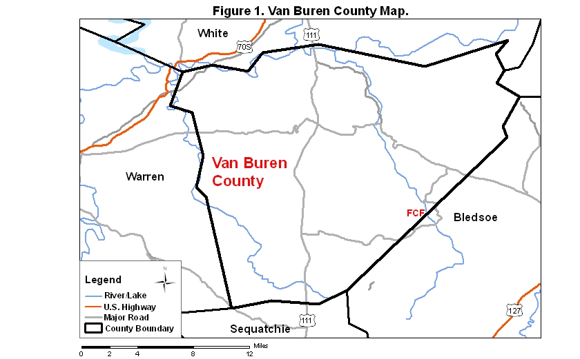
Van Buren County covers an area of 711 km2 (274.6 mi2). A map of the county—with the some sites noted below coded on it—is available via the following link:
By far the most important birding site in Van Buren County (and Bledsoe County) is Fall Creek Falls State Resort Park and Natural Area (FCF). Covering more than 10,000 acres, this park offers many birding opportunities. There are two approaches to the park from the north via Putnam and White counties. For either approach, begin by driving south on Rt. 111 from I-40 about 46.7 km (29 mi) to Spencer, TN. From the intersection of Rts. 111 and 30, you may approach the park from either the north or the southwest. To approach from the north, take Rt. 30 about 17.7 km (11 mi) to Rt. 284, and take Rt. 284 south to the park entrance. Note: Rt. 30 takes you through the Cane Creek Gulf Addition to Fall Creek Falls State Resort Park; it is a wild area, and the winding road through it may cause you to toss your cookies if you are at all prone to motion sickness, which makes the approach to the park from the southwest (described in the next paragraph) a better one for many vehicle occupants.
To approach the park from the southwest, continue south on Rt. 111 from Rt. 30 about 13.2 more km (8.2 mi) and turn left onto Rt. 284 at the sign for the park. Follow the signs about 11.3 km (7 mi) to the park. Rt. 284 to the park is longer than the northern entry route (if you are coming from the north), and it is a bit complicated, so pay attention to the signs for the park as you make your approach. If you are approaching from the south on Rt. 111, go about 32 km (20 mi) north from Dunlap—or 11.3 km [7 mi] north from the intersection of Rts 111 and Rt. 8—and look for the park road (Rt. 284) on the right.
The lake in the park has attracted many species of waterbirds, including Red Phalarope, in the past, but the main attraction of the park is its many miles of woodland trails and woodland birding. Several very short (0.4–1.6 km [0.25–1 mi]) trails are clustered around the Nature Center, offering views of the various falls in the park and access to some of the commoner woodland birds. The Pawpaw Trail is a fairly easy, shortish (6.4 km [4 mi]) loop trail that runs through woodland habitats typical of those found in the park. Two long trails are also available for the hiking birder: the Upper Cane Creek Loop (20.9 km [13 mi]) is fairly flat and offers extensive access to deciduous and mixed forests; and the Lower Cane Creek Loop (19.3 km [12 mi]) provides access to much the same habitat as the Upper Loop provides, but it also accesses a riparian area in the bottom of the Cane Creek Gorge, where Swainson's Warblers might be found some day. The trail down into Cane Creek Gorge along the Lower Cane Creek Loop is steep and treacherous (especially if wet) in places; venture into this gorge only if you are a fit hiker and have lots of time to complete this loop.
A checklist of the park's birds is available at the nature center in the park; a somewhat expanded version of this checklist is available by clicking on the red word in this sentence; it is also available via the park website, a link to which is below:
Please send details about any birds you record in these parks—or any public access site in Van Buren Co.—to me at the e-mail address noted above. sjs.
Quick links to other sections of this website: