Public Access Birding Sites in Smith County, Tennessee
If you have information about other public access birding sites in this county, please send details to me at this e-mail address:
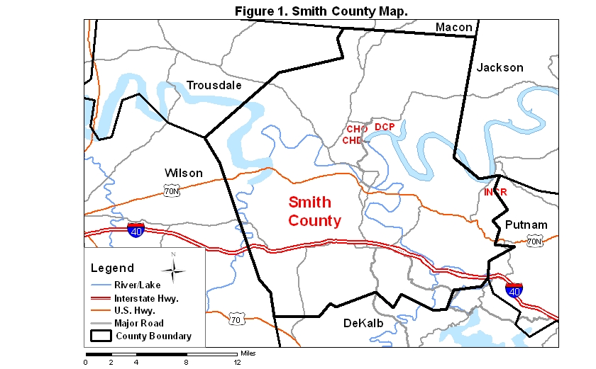
Smith County covers an area of 843 km2 (325.3 mi2). A map of the county—with the some sites noted below coded on it—is available via the following link:
Cordell Hull Reservoir, formed by a dam on the Cumberland River near Carthage, provides many good birding sites in Smith County. Below the dam, the Cumberland River is also a productive area to bird. Some public access sites are described below.
Cordell Hull Dam (CHD) on both the north and south sides of the reservoir/river offers fair birding opportunities during all seasons of the year. To get to the south side of the dam and powerhouse, take I-40 to exit 258, go north on Rt. 53 about 4.5 mi, and take the exit for Rt. 70N; go east on that route 3 mi to Horseshoe Bend Rd. on the left. Follow this winding road 6 mi to a paved road leading off to the right; this road goes 0.9 mi to a boat ramp on the reservoir; birding along this road, especially in the shrub-scrub habitat along it, can be productive at all seasons. Return to Horseshoe Bend Rd. and go right. In 0.7 mi you will come to a fork. The right fork leads to a boat ramp above the dam, and the left fork leads to a boat ramp and other open areas below the dam. The many open fields in this area are good places to listen for American Woodcock at dawn and dusk during winter and spring; this is also a good place to check at dawn and dusk for owls, including Great Horned and Barred.
To get to the dam and powerhouse on the north side, return to Rt. 53 and go north (crossing the Cumberland River and climbing a rather steep hill) about 2.5 mi to a stoplight and intersection with Rt. 263; turn right on Rt. 263 and continue north 2 mi to the entrance rd. to the dam and powerhouse on the right. Drive in about 0.6 miles to the Visitor Center (not open on week-ends) on the left or go 0.2 miles farther and pull into a parking lot also on the left for the the Turkey Creek Nature Trail. This short loop trail features an asphalt-paved, disability-accessible loop of 0.2 mi and a gravel loop of about the same length. To bird the tailwaters below the dam, continue on the road another 0.25 miles and park. Scan the waters below the dam for gulls during winter and migration seasons; Ospreys sometimes appear here as well. Yellow-throated Warblers breed in the riverside trees below the dam.
Once you have completed a look around the north side of the dam site, return to Rt. 263 and go right. In 0.6 mi you will come to a road on the right leading to an area known as the Cordell Hull Overlook (CHO). Besides the panoramic views available from the road and from footpaths leading to high points within this area, this overlook is also the southwestern terminus of the Bearwaller Gap Trail, a longish (7–8 mi), moderately difficult trail that leads to Defeated Creek Park (see below). Birding along this trail can be rewarding, especially during migration seasons. Try to arrange a shuttle so that you don't have to walk this longish trail both ways.
Defeated Creek Park DCP) is located northeast of the Cordell Hull Overlook. From the overlook, go north (right) on Rt. 263, which will intersect with Rt. 85 in 1.6 mi. Go right on Rt. 85 about 2 mi, and the park entrance road is on the right. This park is small enough to cover on foot in 3–4 hours of leisurely walking, or you may drive 1 mi to the end of the road where there are various services, including a boat ramp, picnic area, cabins, restaurant, and campground. The park is also the northeastern terminus of the Bearwaller Gap Trail.
A good place to scan the Cordell Hull Reservoir/Cumberland River is available near the confluence of Indian Creek (INCR) and the reservoir/river in eastern Smith County near Granville (in Jackson County). To get to this site, take Rt. 70N west from Cookeville/Baxter in Putnam County or east from South Carthage in Smith County. In Chestnut Mound, take Rt. 53 north about 3 mi. On the right you will follow the border of Indian Creek, and in another mile you will come to a bridge across this inlet of the reservoir. Stop in the pullout on the right on the far side of the bridge. From the bridge, scope the open area of the reservoir, especially the stump-lined far shore, for waterbirds of various sorts, being careful to watch for traffic on this somewhat narrow bridge. Cliff Swallows nest under the bridge, usually being present late March to early August. Cormorants, gulls, and waterfowl may be viewed during migration and winter. Black Terns favor this area in late summer and early fall.
Please send details about any birds you record in these areas—or any public access site in Smith Co.—to me at the e-mail address noted above. sjs.
Quick links to other sections of this website: