Public Access Birding Sites in Scott County, Tennessee
If you have information about other public access birding sites in this county, please send details to me at this e-mail address:
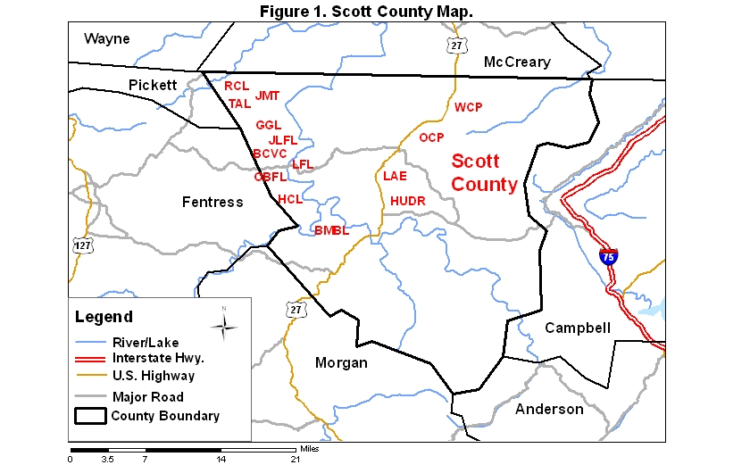
Scott County covers an area of 1381 km2 (533.2 mi2). A map of the county—with the some sites noted below coded on it—is available via the following link:
By far the most important birding site in Scott County is the Big South Fork National River and Recreation Area (BSFNRRA), which constitutes a large fraction of the county. Access to the BSFNRRA may be gained via Rt. 297 from either Jamestown on the west or Oneida on the east. More southerly parts of the BSFNRRA in Scott County may be accessed from Rt. 52 near Elgin on the east or near Allardt on the west. Further information about this site may be found via this link:
Quite a few sites within the portion of the BSFNRRA lying in the county offer worthwhile birding opportunities. Some good birding sites are mentioned below.
The Leatherwood Ford Loop (LFL) (a 4.5-km [3-mi] loop accessible from Rt. 297 at Leatherwood Ford or from the road to the East Rim Overlook).
The Bandy Creek Visitor Center Loop (BCVC) (a 1.6 km [1-mi] loop accessible from the Visitor Center at Bandy Creek).
The John Litton Farm Loop (JLFL) (a 10.5 km [6.5-mi] loop accessible from the swimming pool near Bandy Creek Visitor Center).
Duncan Hollow Rd. (a 6.5-km [4-mi] long gravel road beginning near the swimming pool in the Bandy Creek Campground and ending near Laurel Fork); the fields along this road are specially worth a look for migrant and wintering sparrows.
The Oscar Blevins Farm Loop (OBFL) (a 5.7-km [3.5-mi] loop accessible from the gravel road between Rt. 297 and the Visitor Center).
The 13-km [8-mi] trail on the east side of the Big South Fork from Leatherwood Ford via Angel Falls to Station Camp is well worth a walk if you can arrange a shuttle so that you do not have to walk it both ways. Swainson's Warbler is usually found along this trail in areas where rhododendron is plentiful.
The John Muir Trail (JMT) (a trail running from Divide Road 50 km [30 mil] southeast to Station Camp—with an extension south to Honey Creek planned for the future—and from Divide Rd. northwest 16 km [10 mi] to Pickett State Park).
The Grand Gap Loop (GGL) (a 19.4-km [12-mi] trail that includes a 4.5 km [2.8-mi] stretch from Leatherwood Ford to Angel Falls Overlook, a 10.5-km [6.5 mi] loop, and a 4.5-km [2.8-mi] return stretch from Angel Falls Overlook to Leatherwood Ford).
The Twin Arches Loop (TAL)(a 9-km [5.5-mi] loop accessible from Divide Rd., lying partly in Fentress County).
The Rock Creek Loop (RCL) (accessible from Divide Rd.; this 11.3 km [7-mi] loop lies partly in Pickett County).
More to the south lie the Burnt Mill Bridge (BMBL) (6.8 km [4.2 mi]) and Honey Creek (HCL) (10.5 km [6.5 mi]; difficult) loops.
Most trails in the BSFNRRA run through upland forest or the gorge of the Big South Fork or both; consequently, woodland species dominate the landscape. A few waterbirds can be seen from trails that follow the main river of the Big South Fork. Many sites and trails offer opportunities to hear and sometimes to see Swainson's Warbler. One of the most reliable sites for this retiring warbler is found at the first hairpin turn west of Leatherwood Ford on Rt. 297; another site where this warbler reliably occurs is along the trail on the east side of the river between Leatherwood Ford and Angel Falls. It also occurs along the John Litton Farm Loop and the parts of the John Muir Trail that lie in the gorge.
Oneida City Park (OCP) includes a moderate-sized lake that is often worth checking in migration for transient waterbirds. The park is on the northeast side of Oneida. If you are coming from the south on Rt. 27, continue past the traffic light and left turn for Rt. 297 and go another block or so to the intersection with Rt. 456 on the right (Rt. 27 actually takes a 90 degree left turn at this intersection while the "right" turn for Rt. 456 actually goes straight); take Rt. 456 about 1.2 km [0.75 mi] to the entrance to Oneida City Park on the left; the road into the park has several parking areas on the right, all of which are worth a quick look. There are trails along the west and north sides of the lake that look like they are good for spring and fall migrants. Several large fields in the park have hosted Horned Larks and American Pipits during fall.
Winfield City Park (WCP) is just east of Rt. 27 about 8 km [5 mi] north of Oneida. This park has a large, wettish central field that looks like it could be good for rails and marsh birds during and following rain in the migration seasons.
Lake Elizabeth (LAE) is a small lake located about 3 mi south of Oneida off of Rt. 27. Go south from town on Rt. 27 and just after the road becomes four-lane, look on the left for Underpass Rd. that goes underneath a railroad track. Take this road about 0.4 km [0.25 mi] to the lake on the left; park in one of the lots for the medical facility on the left, preferably the lot next to the lake; then scan the lake (a 'scope is helpful). You can also drive around the lake and view various parts of it from the perimeter roads. The lake usually harbors a few ducks and grebes in winter and might provide habitat for unusual breeding waterbirds to anyone who can explore it by canoe or small boat.
The Huntsville Utility District reservoir (HUDR) is a 250-acre impoundment that sometimes attracts waterbirds; the grassy fields below the dam also are attractive to grassland species. To get to the reservoir, travel east on Rt. 63 from its intersection with Rt. 27; go 2.9 km [1.8 mi] to Water Plant Rd. on the left; take Water Plant Rd. about 0.5 km [0.3 mi] to the water treatment facility building on the right and go right on a gravel road just past the building; take this road through the gate about 0.8 km [0.5 mi] to the top of the reservoir; scope the reservoir from the top of the dam, being sure to go all the way to the far end of the dam.
Please send details about any birds you record in these parks—or any public access site in Scott Co.—to me at the e-mail address noted above. sjs.
Quick links to other sections of this website: