Public Access Birding Sites in Pulaski County, Kentucky
If you have information about other public access birding sites in this county, please send details to this e-mail address:
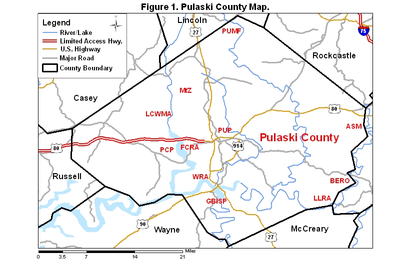
Pulaski County covers an area of 1754 km2 (677.1 mi2). A map of the county—with the some sites noted below coded on it—is available via the following link:
Several sites that are part of the Daniel Boone National Forest (DBNF) are situated within Pulaski County, and each is worth a visit for birds.
One of these DBNF birding sites is known as the Ano Strip Mines (ASM). To get to this nice grassland area, take Rt. 80 east from Somerset about six to eight miles and begin looking for the Shopville School on the left (north); from the school, continue east on Rt. 80 about 3.2 miles and take Rt. 1675 on the right. Go one block to a stop sign and turn left onto Rt. 1675; go 3.8 miles and make a sharp right, staying on Rt. 1675; go another mile and take Acorn Ano Rd. to the left; go 3.2 miles to Bolthouse Ridge Rd. on the right and follow it to the old strip mine area, which includes a short spur to an old cemetery and a trailhead for some trails through the grassland. Another access to the strip mine area can be reached by continuing on Rt. 1675 past Acorn Ano Rd. and watching on the left for the Forest Service access. It is near the Langford/Whetstone Road. Henslow's and Grasshopper sparrows breed in this area. A check-list of species observed at the Ano Strip Mines may be accessed by clicking on the red word at the beginning of this sentence. The topo map for this site is at the following website address:
http://topozone.com/map.asp?z=16&n=4108765&e=737982
The Daniel Boone National Forest
includes another fine birding site known as the Little Lick Recreation Area (LLRA)
(36.9688°N, 84.3943°W).
During the winter of 2001–2002, Northern Saw-whet Owls were found here, and it
features a good population of Swainson's Warblers during the breeding season.
From Somerset at the jct. of Rt. 27 and Bypass 80 (light #
3), go east on Bypass 80 approximately 3 miles; turn right (south) on Bypass 914; go to
the first light in approximately 0.3 miles and turn left (east) on Rt. 192; continue on
Rt. 192 for 14+ miles and then turn right on Old Whitley Rd. (the turn is just
before the Mt. Victory Fire Dept.; Purple Martins formerly nested in the Fire Dept. horns
[!] in season); continue on this road until the blacktop ends and the road becomes FR 122. You will soon come
to a Y; going left on 122A and left again on 5138 at 0.5 miles takes you to a good area for Swainson's Warbler, Blue-headed Vireo and, if you're
lucky, Ruffed Grouse. Back on 122A you'll find several roads to explore; most of the roads at Little Lick dead end and you will have to
backtrack. Going back to the Y and going left from 122A will take you to a horse camp, a trail, and several more roads to explore.
A
check-list
of birds observed at Little Lick may be viewed by clicking on the red word at the
beginning of this sentence. Here is the website for a map to this site:
http://www.topozone.com/map.asp?z=16&n=4094378&e=731967
The Daniel Boone National Forest in Pulaski County also includes a site known as Bee Rock (BERO) (37.0339°N, 84.3263°W), situated along the Rockcastle River in the southeastern part of the county.
From Somerset at the jct. of Rt. 27 and Bypass 80 (light # 3), go east on Bypass 80 approximately 3 miles; turn right (south) on Bypass 914 and go to the first light in approximately 0.3 miles; turn left (east) on Rt. 192 and continue on Rt. 192 approximately 18 miles; turn left just before crossing the Rockcastle River to trails # 529 and # 503. Watch on the left for trail # 529 on the way in; it goes up to an overlook and is 2.2 miles long. To get to trail # 503, continue through the campground and park in the parking area at the end of the road; this trail runs along the river, then goes uphill, crosses Close Road, and intersects with trail # 529, which you can take back down to the main road and then go left back to the parking area for a distance of 6+ miles. Along the road before the campground watch for Prothonotary Warblers along the river, listen for Swainson's and Cerulean warblers along the river on trail # 503, and look for Blue-headed Vireos up on top along trail # 529. Grouse are possible anywhere. Going back west on Hwy. 192, watch on the right for Close Road; it's also within the DBNF and is a good road to bird. A check-list of birds observed at Bee Rock may be viewed by clicking on the red word at the beginning of this sentence. Here is the website for a map of this area:
http://www.topozone.com/map.asp?z=16&n=4101775&e=737819
For the Alpine Recreation Area go south from Burnside on Rt. 27 past Alpine and watch on west (right) side for the Alpine Recreation Area. There's a picnic area, a loop trail and a forest service road. A checklist of species for this area may be viewed by clicking on the red word at the beginning of this sentence. To see the Forest Service website for further details about this site and to view a map of the site, click below:
http://www.fs.fed.us/outernet/r8/boone/documents/rogs/somerset/picalpine.pdf
http://www.topozone.com/map.asp?lat=36.91575&lon=-84.51634&size=l&u=4&datum=nad27&layer=DRG
Another good birding area in Pulaski County is the Waitsboro Recreation Area (WRA), a Corps of Engineers site located on the north shore of Lake Cumberland. From the intersection of Rts. 27 and 90, go north on Rt. 27 about 1.5 mi to traffic light # 29; go left one block; go left again for a block; then go right downhill about a half mile to a point just before the gate to the campground and scan the lake for waterbirds. The campground is closed in winter and makes for a good woodland birdwalk at that time. A check-list of birds observed at Waitsboro may be viewed by clicking on the red word at the beginning of this sentence.
It is possible to scan Lake Cumberland from a public boat ramp that is slightly west of the Waitsboro Recreation Area, but on the south side of the lake. Return to Rt. 27 and take it south to Rt. 90; turn right (west) on Hwy. 90 and go 1.7 miles; turn right on Old 90 Loop Road (just east of the Bronston Post Office); go 0.8 mi. and turn right at the 3-way stop (Waitsboro Road); go to the end of this road and park in the parking area above the boat ramp; then walk down the ramp and scan the lake.
The Fishing Creek Recreation Area (FCRA) still another good birding spot in Pulaski County, is also a Corps of Engineers site, located on an arm of Lake Cumberland. To get to Fishing Creek from the intersection of Rt. 27 and Business Rt. 80 (light # 4 in Somerset), go west on Rt. 80 about 2.8 miles to Rt. 1248 on the right (a Shell station is at this corner); take Rt. 1248 about 1.6 miles to the end of the road. Scan the lake from this point for divers and other waterbirds. If you have a boat, the mudflats back up the creek to the right about 0.5 mi are good for shorebirds when the lake has been drawn down to winter-pool level; the draw-down usually starts in September. A check-list of birds seen in the vicinity of Fishing Creek, an arm of Lake Cumberland, may be viewed by clicking on the red word at the beginning of this sentence.
Lee's Ford Dock is also worth a trip if you are in the area of the Fishing Creek Recreation Area. From the intersection of West Hwy. 80 and Rt. 27 (light # 4), take West Hwy. 80. At about 5.5 miles turn left and go to the end of the road; this road will be an immediate left after crossing the Fishing Creek bridge. Great Blue Herons nest on the island across from the marina; this site is the only public place to watch their nesting cycle in Pulaski County, which begins in February. After the leaves come out, the heron nests are harder to observe. The area is a good for Red-headed Woodpeckers year-round, and there are usually a few gulls hanging around the marina in winter. A check-list of birds seen in the vicinity of Fishing Creek, an arm of Lake Cumberland, may be viewed by clicking on the red word at the beginning of this sentence.
A number of birding sites on the shores of
Lake Cumberland are collectively known as the Lake Cumberland Wildlife
Management Area (LCWMA), owned, like Fishing Creek and Waitsboro, by the Corps of
Engineers but managed by the Kentucky Department of Fish and Wildlife Resources. It
is composed of bottomland that is flooded during heavy rains. It contains woodland, strip mowed fields, corn and soybean fields, and
ponds managed for waterfowl. Some of these sites, all located in Pulaski
County, are described in the following paragraphs. [Other sites in Russell
and Wayne counties are also part of Lake Cumberland WMA.]
High Rock or Wesley Bend Unit
(coordinates 37.1394° N; 84.7188° W). Two ponds in this area are managed for waterfowl and
closed October 15–March 15 each year. This site is very good for wildflowers,
including bird's-foot violet.
From Somerset at the intersection of Rt. 27 and Bypass 80, go north on Hwy. 27 for
0.5 mi and turn left on Clifty Rd.; take Clifty Rd. 4.1 miles and, just after crossing Clifty
Creek, turn left (you will still be on Clifty Road; there's a binocular sign at the turn);
go 1.6 mi; the road ends at Beech Grove Rd. Turn left on Beech Grove and go about
0.4 mi past the Beech Grove Church; turn right on Wesley East Rd. and go to the bottom of the hill. On the left
there is a gated road; walking it will take you to a seasonal pond on the right and fields and woods bordering Fishing Creek. Straight
ahead there is another gated road, leading to a seasonal pond on the left, strip mowed fields, and trees bordering Fishing Creek.
http://www.topozone.com/map.asp?z=16&n=4112565&e=702625&u=
Oil Center Areas. One access is to follow the above directions for High Rock to Wesley East Rd., but continue on Beech Grove Rd. for another 2.4
mi; at the junction going left leads to the mouth of Clifty Creek and going right
leads to Fishing Creek where there is a makeshift boat ramp. During heavy spring rains the creek backs up into
the woods and fields.
http://www.topozone.com/map.asp?z=16&n=4108907&e=704718&u=1
Ringgold Road, Oil Center access (coordinates 37.1084° N, 84.6900° W). To
get to this site from the junction of Rt. 27 and Bypass 80, go west on Bypass 80 and turn right on
Rt. 3263 (Ringgold Rd.), continue to end of the road.
This site is good for early spring migrants and is one of the few places in the county where Prothonontary Warblers breed. This
site includes the mouth of Clifty Creek, which runs into Fishing Creek, which
becomes the backwater of the Lake Cumberland at summer pool level. If you walk up on the hill on
the left, you'll reach a very rough path to walk for woodland birding. There is
a launch site for boats when the water level allows.
http://www.topozone.com/map.asp?z=16&n=4109192&e=705267&u=1
Oil Center/Pointer Creek/Coldweather Creek area. From the junction of Rt. 27 and
Rt. 635 in Science Hill, go west on Rt. 635 and continue through town; Rt. 635
bears right at the T-intersection; then turn left at the stop sign. Watch on the
left for Rt. 1676 (it will be approximately 1.5 miles from the 27/635 junction); turn
left on Rt. 1676 and after 2 mi turn left at the T; continue on Rt. 1676 past the 5 mile marker at Mofield Rd.
and go to next road and turn left on Spaw Cemetery Rd.; go 1.7 mi and turn left at
junction; after 2.1 mi go right at junction (going left will take you along the creek and bring you out on Mofield Rd. to Hwy. 1676, but the road is sometimes gated off)
and cross the creek; at 3.2 miles turn left at T. Reset mileage enter the WMA; go 1.7
mi to junction and turn left; this area has a pond that is a waterfowl refuge and will be closed
October 15–March 15. The area has a makeshift boat ramp.
http://www.topozone.com/map.asp?z=16&n=4109476&e=703194&u=1
Across the lake from the end of the road at the Fishing Creek Recreation Area (see above) is Pulaski County Park (PCP), which can be accessed by returning to Rt. 80 and driving west; watch on the right for the Pulaski County Park sign. There is a walking trail in the park that goes through the woods and crosses a couple of small branches; the park also features a picnic area, a camping area, and two boat ramps. Here is the website for a map of this area:
http://www.topozone.com/map.asp?z=16&n=4104782&e=704393&u=1
A check-list of birds seen at Pulaski County Park may be viewed by clicking on the red word at the beginning of this sentence.
Another birding site in Pulaski County is General Burnside Island State Park (GBISP). Go south on Rt. 90 about 1.7 mi from the intersection of Rts. 27 and 90 and turn right to the park. In 0.7 mi you will come to a road on the left that leads to a boat launch; you can scan the lake from here. The park is on an island and offers fairly good woodland birding in spring, summer, and fall. A check-list of birds seen at General Burnside Island State Park may be viewed by clicking on the red word at the beginning of this sentence.
To reach the Cathy Crockett Trail, sponsored by the Kentucky Rails to Trails Council, go south from Burnside on Rt. 27 to Sloan's Valley about 8 km (5 mi), watching on the west (right) side of highway for a sign for the trail reading "LCTF." A check-list of birds observed along this trail may be viewed by clicking on the red word at the beginning of this sentence.
The ponds at the Twin Lakes subdivision
can provide good birding. Get to them by beginning at the junction of Rt. 27 & Bypass 80.
Go east on Bypass 80 approx. 0.5 mi and turn left on Rt. 1247; go 1.5 mi
and turn right at Twin Lakes subdivision (just past Oak Leaf sign). There
is a pond on the left and a spill-over pond on the right. The latter is usually the most productive. Continue on
this road to a T-intersection and turn right; go to a second road on the right
and turn right; go up a hill and turn left at first road; you will see a pond down over the
hill; go to another T and turn left, viewing the pond from the roadside. A check-list
of birds observed at Twin Lakes may be viewed by clicking on the red word at the
beginning of this sentence. [For Pumphouse Pond
(described below) continue on this road bearing right when there is a choice; go to T-intersection
and turn left to end; this will be Rt. 39; turn right and go 0.2 mi and turn left on Old
Pumphouse Rd. (gravel).] Here is a link to a map of the area:
http://www.topozone.com/map.asp?z=16&n=4110431&e=712988
Pumphouse Pond (PUP) is a consistently
productive birding site in
Somerset. From the junction of Bypass 80 & Hwy. 27, take Bypass 80
east; go to Rt. 39 and turn left; go past the Pulaski County High School; watch on the right (just past the YMCA) for Old Pumphouse Road;
the pond is on this road. A check-list
of birds observed at Pumphouse Pond may be viewed by clicking on the red word at the
beginning of this sentence. Here is a link to a map of the area:
http://www.topozone.com/map.asp?z=16&n=4109740&e=713923
The Mount Zion community (MtZ) is another
site in Pulaski County with a pond that offers good birding opportunities,
mainly from the roadside.
From the junction of Rts. 27 and 635 in Science Hill (north of Somerset), go west on
Rt. 635. Continue through town, and Rt. 635 will go right at a T-intersection
and then left at a stop sign. After going a total of approximately 1.5 mi
from Rt. 27, turn left on Rt. 1676. In approximately 1 mile, there is a pond on the left
that attracts shorebirds and waterfowl in the proper seasons. A
check-list
of birds observed in the Mt. Zion community may be viewed by clicking on the red
word at the
beginning of this sentence. Here is a link to a map of the area:
http://www.topozone.com/map.asp?lat=37.18417&lon=-84.67639
The Valley Oaks Technology Park offers
birding at three retention ponds that attract waterbirds and shorebirds in
season. From the intersection of
Rts. 80 and 461 go north on 461 about 1–2 miles. Watch for the sign for
Valley Oaks Technology Park on the left and turn left. The road forms a
semi-circle about 0.5 mi long; it curves back to the south, reconnecting with
Rt. 461 (you can enter either way, but the sign is at the north end). A
large pond (with an stone-covered island in the middle) is located on the east
side of the road and two smaller ponds are on the west side. Spotted, Solitary,
and Least sandpipers have been sighted in two of the ponds; four species of
ducks and Pied-billed Grebe have occurred on the other pond. The ponds
will probably remain for retention, but future development in the park may
discourage migrants though that is not yet the case.
A fairly new addition to the public access birding sites in Pulaski County is the Buck Creek Nature Preserve (Pumphrey Tract) (PUMF), jointly owned and administered by the county and The Nature Conservancy. To get to this site from the intersection of Rt. 27 and Rt. 70 at Eubank, go east on Rt. 70 for 5.1 miles to Rt. 865 and turn left. To visit the the south end of the farm, go 0.5 miles to E. Fairview Rd. and turn left; go to the end of the road where a gate is visible ahead, park , and walk the property. To visit the north end of the farm, continue on Rt. 865 past E. Fairview Rd. another 0.5 mile and turn left on Goodhope Estes School Rd.; then go 0.8 mile and turn left on Goodhope Goochtown Rd. and continue to Buck Creek. The property lies on either side of the road as you come down the hill toward the creek. The wooded areas belong to Pulaski County, and trails are planned. The fields along the creek belong to The Nature Conservancy and are being restored to native vegetation. A check-list of birds observed at the Pumphrey Tract may be viewed by clicking on the red word at the beginning of this sentence.
Many thanks to Roseanna Denton, Connie Neeley, and Laura Kamperman for information included in most of the above paragraphs.
Please send details about any birds you record at these sites—or any public access site in Pulaski Co.—to the e-mail address noted above. sjs.
Quick links to other sections of this website: