Public Access Birding Sites in DeKalb County, Tennessee
If you have information about other public access birding sites in this county, please send details to me at this e-mail address:
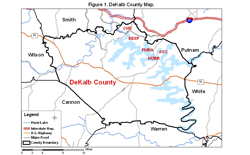
DeKalb County covers an area of 852 km2 (329 mi2). A map of the county—with the some sites noted below coded on it—is available via the following link:
Edgar Evins State Park (EESP), located on Center Hill Lake, is one of the most attractive of the birding sites available in DeKalb County. To find the park, take exit 268 from I-40 and go south on Rt. 96 about five miles to the intersection with Rt. 141; the entrance to the park is directly across the road from this intersection.
The park consists mainly of wooded hillsides that lead down to Center Hill Lake; in summer many species of warblers breed on these hillsides, including Cerulean Warblers on and near the ridgetops and Prothonotary Warblers along the lake edges. In winter the many cedar thickets at the lower elevations of the park's hillsides harbor a diverse array of passerines, including some scarce winter residents such as Blue-headed Vireo.
Several trails that are good for birds may be hiked by those who like to do their birding on foot: the Highland Rim Trail (a loop of about 2 miles) begins and ends near the Visitor Center; a trail (about a mile long) that connects the marina to the campground; a (somewhat poorly marked) loop trail (about a mile long) at the beginning of the road to the cabins; and a longer set of trails with a trailhead located midway between the road to the marina and the road to the campground. The last set of trails is fairly extensive, but not all the trails are yet well marked, so be cautious about proceeding on them; in winter be especially cautious as many of the trails pass through areas that are open to hunting.
Some viewing access to the lake is available at the marina and at the two boat ramps at the end of the park roads. The ramp at the very end of the park road includes a rocky peninsula that is above the winter pool level of the lake and may be walked to its end where loons, grebes, and gulls are often in view. In summer this peninsula is under water; a small rookery of Great Blue Herons is located in the trees at the end of the peninsula.
An incomplete checklist of the birds of the park may be viewed by clicking on the red word at the beginning of this sentence.
The Casey Cove Campground (closed but accessible) in the Holmes Creek Recreation Area includes an old campground and picnic area that offer good woodland birding, as well as some views of the Holmes Creek arm of Center Hill Lake. Get to this site from Smithville. Drive west on Rt. 70S from Rt. 56 and look for the Smithville High School on the right; after passing the high school, look for Rt. 83 on the right; continue past Rt. 83 on Rt. 70s and go 0.6 mi to Hurricane Ridge Rd. on the right; take Hurricane Ridge Rd. 5.5 mi to a boat launch site, from which it is worth having a look for waterbirds; just before the boat launch on the right is the gated entrance to the old Casey Creek Campground; park opposite the gate and walk in, going uphill to a central intersection. Walk both campground loops (about 0.5 mi each) and also walk straight ahead to a boat ramp, from which one may obtain another view of the lake. Horned Grebes sometimes winter on this arm of the lake, and the woods of the campground are good for passerines most times of the year. Cerulean Warblers nest in the campground, usually along the first road to the right after you walk up from the gate. To view a check-list of birds so far observed at this site, mainly during 2005 by Carol Williams, Judy Fuson, and Michael Hawkins as part of Project Parkwatch, click on the red word near the beginning of this sentence. Note: there are plans to move the Hidden Cove Marina to Casey Cove, a move that will vastly change the birding status of this site.
Center Hill Dam (CHD) offers good views of the lake and of the tailwaters of the dam along the Caney Fork River. To get to the dam, take exit 268 from I-40 and go south on Rt. 96 about five miles to the intersection with Rt. 141; turn right on Rt. 141 and go about a mile to the dam.
In winter the lake sometimes harbors loons and grebes, while the river below the dam occasionally hosts a Bald Eagle.
Below the dam the Buffalo Valley Nature Trail, a short loop trail, may be accessed from Rt. 141 about a half mile before getting to the dam. Take the road to the Resource Manager's Office and to the boat launch; park near the restroom and walk the trail to where it ends (in 0.3 miles) at a bench by the river. Black Vultures sometimes winter near this site in large numbers. To view a check-list of birds so far observed at this site, mainly during 2006-2007 by Winston A. Walden as part of Project Parkwatch, click on the red word near the beginning of this sentence.
The Floating Mill Recreation Area (FMRA) is a good site to scan for waterbirds during fall, winter and spring. To find this site, take exit 273 off I-40 and go south about 3.5 miles to a road on the right marked for Hurricane Marina and Floating Mill Recreation Area. Go downhill a bit less than a mile and take a right at the small market (take the middle of three roads to the right here); this road will lead down to a boat ramp and campground. From November through March the campground is closed, but you may scan the lake from the boat ramp or walk down the road into the campground about 0.25 miles to a point where the road borders the lake and offers good viewing. From April to October, this facility is open; inquire at the entrance gate to either the boat ramp or the campground and say that you are birding and that you will be quiet. A flock of 100+ Horned Grebes stays at this site every winter; loons are regular from November to January and from March to April; and Bald Eagles are occasional visitors to this site.
|
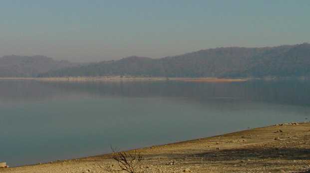
| Hazy scene from the campground in Floating Mill Recreation Area, Center Hill Lake, DeKalb Co., TN; the sandbar in the background is Moss Island, which harbors a small rookery of Great Blue Herons; photo SJS. |
The Lost Spring Trail, a loop trail about 1.2 miles long, begins at the gate to the campground; go past the gate and immediately look on the left for the beginning of the trail. This trail is quite steep for about a half mile, so wear appropriate footgear if you decide to walk it. Cerulean Warblers usually breed near the top of the hillside along the trail.
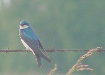
The area around the Hurricane Bridge (HUBR) on Rt. 56 can be productive for birds. If you are traveling from I-40 to Smithville, look for a scenic overlook of Center Hill Lake on the left about a third of a mile past the road to Floating Mill and Hurricane Marina (and a mile or so before you get to the bridge); this overlook offers nice views of the lake, as well as a chance for distant views of loons, grebes, and eagles. About a half mile before the bridge there is a grassy field on the left where Tree Swallows (see below) nest in bluebird boxes in summer and where sparrows may be found in winter. Just before the bridge there is an access road on the right to a boat ramp and campground. The campground has been closed year-round in recent years, so it makes a good place to walk and look for birds, while the boat ramp offers a place to scope the lake for loons, grebes, gulls, and other waterbirds.
 |
|
| Tree Swallow near a nesting site in DeKalb Co., late June 2003; photo Carol D. Williams. |
The Appalachian Center for Crafts (ACC), accessible by a road on the left just after you cross Hurricane Bridge, offers several attractions to the traveling birder. About a mile up the road to the center, there is a short road on the right leading to the Berry C. Williams Overlook, from which distant views of the lake may be had. Several hiking trails on the Craft Center grounds, collectively known as the William Stacy Trail System, can be walked for birds productively most of the year, but especially during the breeding season. A brochure and map to the trail system is available at the visitor center. The Hook Trail (moderate difficulty) is located at the end of the road to the Craft Center. To access it, park in the lot for the visitor center and walk toward the housing area beyond the visitor center; cross the road, and look for a small garden; the Hook Trail begins on the far side of garden at the edge of a steep hillside; it is a loop trail about 1.3 miles long, offering two access points to the lake and passing through a variety of woodlands. The Pedigo Point Trail (difficult because quite steep in places) is 1.4 miles long (one way); it leads to a primitive camping site where good views of the lake are available; the forest along the way is variable and generally fairly good for birds. The beginning of this trail is about 100 m toward the end of the road after you pass a gated log road on the right. Another trail in the system that is a bit less well marked than these two trails is the Loop Trail, which begins about 25 m before the same gated log road; it ends near the Berry C. Williams Overlook.
Please send details about any birds you record in these sites—or any public access site in DeKalb Co.—to me at the e-mail address noted above. sjs.
Quick links to other sections of this website: