Public Access Birding Sites in Cumberland County, Tennessee
If you have information about other public access birding sites in this county, please send details to me at this e-mail address:
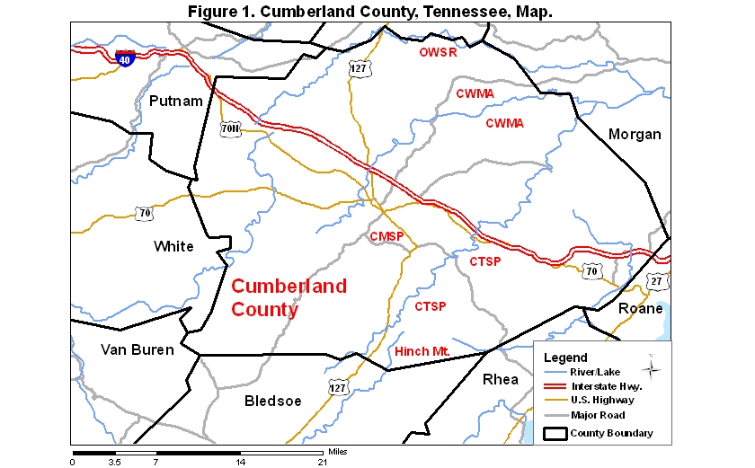
Cumberland County covers an area of 1774 km2 (684.9 mi2). A map of the county—with the some sites noted below coded on it—is available via the following link:
Cumberland Mountain State Park (CMSP), located about five miles east of Crossville off Rt. 127 (1.2 miles east of the intersection of Rts. 127 and 68), offers some fine trails that are suitable for birding. The loop that begins at the dam and goes up the lake is about five miles long; the loop that begins at the dam and goes downstream away from the lake is about eight miles long. Either provides good opportunity to see and to hear numerous woodland species. Ruffed Grouse has been noted along the latter of these trails. The lake occasionally provides a stopover site for small numbers of waterfowl. An incomplete checklist of about 100 species of birds noted in the park may be viewed by clicking on the red word at the beginning of this sentence.
The northern end of the Black Mountain Section of Cumberland Trail State Park (CTSP), located just off I-40 (exit 329), is situated at an elevation of 850 m (2800 ft), high enough to harbor nesting Chestnut-sided Warblers and perhaps other species preferring moderately high elevation at which to breed. Take exit 329 and go directly south about 2.7 km (1.7 mi) to an intersection with a paved road on the left; take that road 4.8 km (3 mi) to the top of the mountain where there is a parking lot. Trails run through of this 200-hectare (500-acre) site, which is mostly wooded, but a few overlooks offer views of the surrounding countryside. The Black Mountain Section of the Cumberland Trail runs generally southwest from the top of the mountain for about 6.4 km (4 mi) to Cox Valley Road. Note: this section of the trail is scheduled to undergo some moderate changes designed to terminate the trail on Rt. 68 rather than on Cox Valley Rd. in the future
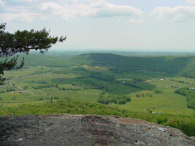
The Brady Mountain Section of Cumberland Trail State Park begins about 0.6 km (0.4 mi) east of Cox Valley Rd. on the south side of Rt. 68; this trail runs about 12 km (8 mi) south along the top of Brady Mountain to Jewett Rd. Much of the trail lies above 750 m (2500 ft). A side trail about 3.2 km (2 mi) from the north end of the trail leads to Brady Bluff Overlook which offers a fine panoramic view of Grassy Cove; there are two additional (somewhat tree-obscured) overlooks--Lost Overlook and Donnelly Overlook--about 6.4 km (4 mi) and 9.6 km (6 mi), respectively, from the north end. None of these side trails is well marked, so try to visit the site for the first time with someone who knows where they are. This entire section of the trail provides very good woodland birding opportunities, with probably the best birding being found on Dorton Knob near the southern end of the section. Veeries, Canada Warblers, and Rose-breasted Grosbeaks have been documented to be present during the breeding season on the northeast slope of Dorton Knob.
|
|
| View of Grassy Cove from Brady Bluff Overlook, Brady Mountain section of Cumberland Trail State Park 17 May 2007; photo SJS. |
To get to the southern end of this section of trail, go east on Rt. 68 from Cox Valley Rd. about 12.8 km (8 mi) to Jewett Rd. on the right (a sign for Reed's Chapel is also at this intersection; Jewett Rd. is 1.3 km [0.8 mi] east of the Thomas Burnett Bridge over White's Creek). Take Jewett Rd. about 11 km (6.9 mi) to the (difficult to see) trailhead sign on the right; the last 3.7 km (2.3-mi) section of this road to the trailhead is graveled; if you get to the road to Hinch Mountain (on the left) you have gone about 0.6 km (0.3 mi) past the trailhead. Click on the "More" button at the bottom of this page, and then scroll down to the fifth photo at the bottom of the page that comes up to see one of the more imposing denizens of the mountain that one might encounter along this trail.
 |
|
| Birder and mountain laurel along the Brady Mountain Section of Cumberland Trail State Park 17 May 2007; photo Jim McCullough. |
Another completed section of the Cumberland Trail that is about 22.4 km (14 mi) long runs along Daddy's Creek and the Obed River in Cumberland and Morgan counties; this rugged section of trail lies mostly in the Catoosa WMA (see below), but a part of it is in the Obed Wild and Scenic River (see below).
Preliminary check-lists of birds (90 species) and butterflies (30 species) I have recorded along the Black, Brady, and Catoosa sections of Cumberland Trail State Park may be viewed at a page accessible via this link:
The Catoosa Wildlife Management Area (CWMA), a 32,250-hectare (80,000-acre) site located mainly in Cumberland County, is fragmented by numerous gravel roads accessing upland forests of a variety of types, as well as creek bottoms; recent efforts to create an oak savannah have also been undertaken and seem to be meeting with success. Access to this site is available from I-40 at exit 322 (Peavine Rd.) and at exit 320 (Genesis Rd.). During February and March, as well as on many week-ends when big game hunting takes place, the area is closed, so be sure to check its availability before entering it.
Part of the Cumberland Trail follows Daddy's Creek within the Catoosa WMA property. Birding along the trail is often productive in spring and early summer; again, be sure the area is open before hiking in the Catoosa.
Formerly one of the last remaining breeding sites of Red-cockaded Woodpecker in Tennessee, the Catoosa now lacks this conifer-loving woodpecker, but it still provides habitat for an abundant avifauna of Neotropical migrants. Dead pines following the pine beetle outbreak of 2000–2002 and dead deciduous trees resulting from forest management practices made some parts of the Catoosa, especially along Firetower Rd., an excellent site for Red-headed Woodpeckers.
The Obed Wild and Scenic River (OWSR) is a federal site lying partly in Cumberland County. The OWSR is a linear site with areas of the Catoosa WMA bordering it on both sides of the river. Access to launch sites on the river occurs at Adams Bridge on Genesis Rd. and Potter's Ford Bridge on Potter's Ford Rd. Canoe-birding along most stretches of the river in both Cumberland and Morgan counties requires good canoeing skills. While the river is technically accessible at any time of year, access actually depends on the occurrence of sufficient rainfall and on whether or not the Catoosa WMA, through which one must drive to some access points, is open or closed. A list of about 140 species recorded throughout the OWSR, including portions in Morgan County, Tennessee, may be found in Stedman and Stedman (2002).
Hinch Mountain, situated about 18 miles southeast of Crossville, is the site of an FAA installation. Take Rt. 127 southeast from Crossville and go 0.8 miles past the entrance to Cumberland Mountain State Park (on the right); then take Old Rt. 28 on left (just past a Texaco Station on the left) about 3.7 miles to a gravel road on the left (this gravel road is 0.7 miles past the Sutton Dam bridge over Daddy's Creek on Old Rt. 28); take this gravel road 3.9 miles to another gravel road on the right; take that gravel road to the top of the mountain (about 2.9 miles). A four-wheeler track encircles the top of the mountain, and trees have been cleared from the top, providing spectacular views of the Sequatchie Valley to the south and Brady and Bear Den mountains to the north. Note: the very top of Hinch Mountain has been fenced by the FAA and is off-limits to visitors, but the area outside the fence appears to be open to use; however, enter it at your own risk.
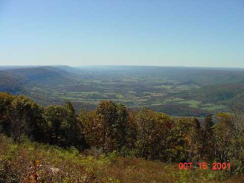 |
| View from the top of Hinch Mountain south along the northern end of Sequatchie Valley, Cumberland Co., TN; photo by SJS. |
Hinch Mountain rises to a height of 3049 feet, allowing it to harbor breeding Chestnut-sided Warblers every year. Other high elevation specialists, such as Rose-breasted Grosbeak and Black-billed Cuckoo, occur somewhat more sporadically. This site offers opportunities for hawk-watching to anyone willing to make the drive up the mountain from mid-September through November, but finding a suitable location from which to count while not being run over by four-wheelers could prove difficult; and since 2005 the top of the mountain has been fenced off (to discourage vandalism).
A small portion of the Bridgestone/Firestone Centennial Wilderness lies in extreme western Cumberland County south of Rt. 70; most of that rather productive public access site is situated within White County, so access the page for public access sites in that county for a description of it.
Please send details about any birds you record in these areas—or at any public access site in Cumberland Co., TN—to me at the e-mail address noted above. sjs.
Literature Cited
Quick links to other sections of this website: