Public Access Birding Sites in Clay County, Tennessee
If you have information about other public access birding sites in this county, please send details to me at this e-mail address:
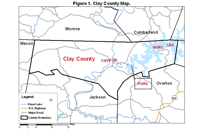
Clay County covers an area of 672 km2 (259.3 mi2). Some of the sites noted below are coded on a map available via the following link:
The main birding attractions in Clay County are associated with Dale Hollow Lake. There are many private sites around the lake that are accessible, but three public sites of interest are described below.
The Pleasant Grove Recreation Area (PGRA), located near the dam at the western end of the Dale Hollow Lake, is a moderately good site to scope for waterbirds during fall, winter, and spring. A short trail offers opportunities to see and hear migrants and resident breeding species as well. To get to this site, take Rt. 53 north out of Celina. A few miles north, watch on the right for a sign for and road to Dale Hollow National Fish Hatchery. From this intersection, continue north on Rt. 53 another 0.4 mi to the next road on the right; take this road 0.7 mi to an intersection with a road on the right (a somewhat battered sign for Pleasant Grove is posted at this intersection); take this road to the right 0.7 more mi to another road coming in on the right (there is another sign for Pleasant Grove at this intersection); from this intersection you may go straight 0.25 mi to a private boat ramp where you may scope the lake and/or take the road to the right to the parking lot for Pleasant Grove, where there is a public restroom (open only during the warmer months).
Willow Grove (WGRA) and the Lillydale Recreation Area (LRA) are located on the south side of the lake and can be accessed only via Overton County. To get to either of these adjacent areas, go north from Livingston 3–4 mi on Rt. 111 and watch on the left for Rt. 294, which junctions with Rt. 111 in a long downhill grade. Take Rt. 294 about 14 miles to a sign marking a road on the right for Lillydale (this road is also 5.6 mi past the Overton/Clay county line). From this intersection you may go straight another 2.5 miles to Willow Grove or right 0.95 mi to Lillydale.
If you go to Willow Grove, you may wish to scope the lake from a bluff that can be accessed from a private circular road near the end of Rt. 294; take this road to the right just before you get to the end of Rt. 294 and drive about half way around the circle, parking where you can see through the trees to the lake. Scope the lake from this site, especially searching to the far right.
If you go to Lillydale, go 0.95 mi downhill and turn onto the first road to the right and drive 0.25 mi to a boat ramp, from which good views of the lake can be had. You may also walk through the adjacent picnic area and campground during winter months when they are not in use. These sites offer several additional areas where you can scope the lake for waterbirds and eagles.
A trail along and near the lake connects Willow Grove and Lillydale; this trail is supposed to be five miles long, but I have walked it several times, and I am sure it is considerably longer than that; also, it is usually not maintained often enough to prevent walkers from having to climb over numerous deadfalls. To find the west end of this trail, look on your right about 0.3 mi from the end of Rt. 294 for the trailhead. Note: avoid this trail during hunting seasons unless you crave the sound of gunblasts.
Further information about this site may be found via this link:
The Celina Wastewater Treatment Plant (CWTP) is located next to the Cumberland River about 2 miles from the Clay County Courthouse. If you are on Rt. 53 coming from Gainesboro, look for Rt. 52 going north (not south) on the left and take it until you come to a four-way stop in less than a mile; turn left, passing the courthouse (on your right) and continuing straight, past the courthouse and along a road that goes through a subdivision in river bottomland. Go left on Breyer Rd. and at the next stop sign go left and proceed to the end of the road where the wastewater treatment plant is located; if the gate is open, drive in about 50-100 feet and park on the right; then walk carefully to the levee and see what is in the lagoons; it is okay to walk the levees if you are quiet. If the gate is closed, park at the gate and walk toward the river; at the end of the chain-link fence, go past it and carefully climb through or over the lower wire fence to enter the area where the lagoons are located. Be careful not to damage the fence—or yourself—when you go through or over it. A check-list of birds recorded at this site, mainly by Terry M. Campbell as part of Project ParkWatch, may be accessed by clicking on the red word near the beginning of this sentence.
Donaldson Park (DP) located on the Obey River in Celina, contains much fair birding habitat at all seasons of the year. To get to it coming from Gainesboro on Rt. 53 or from Livingston via Rts. 52 and 53, turn left at Rite Aid (where there is a the blinking light just past Dairy Queen). Follow this road past the old Celina High School (on left) less than a mile to a 4-way stop sign. Turn right, go c. 0.2 miles (just past the Baptist Church), and turn left at Randell's Garage on Jefferson St. (there is a sign for Donaldson Park sign here). Go to stop sign and go right but do not take dead end street to right ninety degrees; go past exotic animal farm and go right into park.
Many thanks to Terry M. Campbell for information contained in several of the above paragraphs.
Please send details about any birds you record in these parks—or any public access site in Clay Co.—to me at the e-mail address noted above. sjs.
Quick links to other sections of this website: